The Map rendering: a topographic map in relief
A modern map, drawn for your poster, on the 3D relief
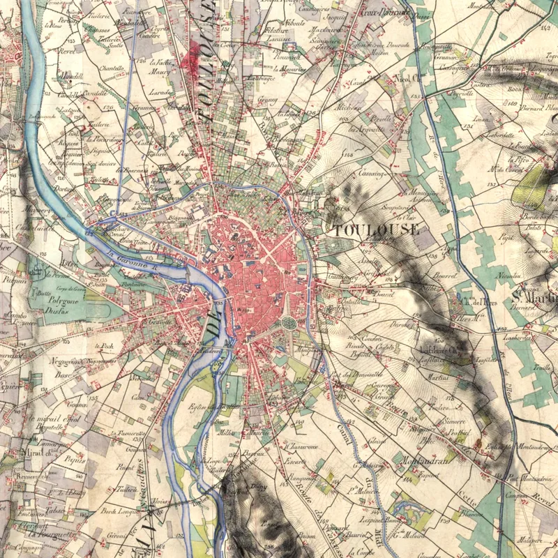
The Map rendering draws a real topographic map of your place and lays it on the real relief of the land, in 3D. Villages, roads, paths, forests, summits and their heights: everything you expect from a fine map, with the mountains and valleys in volume, anywhere in the world.
A map drawn for the poster
The map comes from OpenStreetMap, the great map of the world kept up to date by millions of contributors. We draw it again for the poster: the level of detail follows the scale of the area, and the names are written to stay readable once printed. Over a valley, you follow the roads, the paths and the streams; over a massif or a region, the towns, the main roads, the summits and the names of the massifs, valleys and islands remain.
The names are laid flat on the final image: they stay sharp, even in the shadow of the mountains.
Two styles
- Classic: today's map, clear and readable. Towns and roads come first, with the railways, the mountain passes and their heights, the broadleaf and conifer forests, the contour lines, the rocks, the glaciers and the depths of the sea.
- Mountain: the hikers' map. The waymarked paths and the long-distance GR trails in red, the summits, passes and huts with their heights, the names of the massifs, valleys and glaciers first. Over large areas, only the GR trails remain.
Every creation gives both styles: you then choose the one to print.
How it is made
Under the map, the relief comes from the best models available: the IGN's in France, the national models of some fifteen countries and regions, joined at the borders, and the global Copernicus model elsewhere. The sea floor comes from SHOM, EMODnet or GMRT, the vegetation from the European satellites. The relief is exaggerated to be readable, then lit by a low sun from the north-west, as on mountain maps.
Strengths
- A real, readable map, with the place names and heights.
- The real relief in volume under the map, its forests, rocks and glaciers.
- Anywhere in the world, from a valley to a whole region.
- Two styles for the same area, one of them for hikers.
Limits to know
- The detail depends on the scale: over a large area, only the towns, the main roads and the main summits remain.
- The quality of the names, paths and heights depends on the OpenStreetMap contributors of the region; a summit with no known height is not shown.
- In the plains, the relief stays discreet: the map makes the image.
- From 300 to 90,000 km²: below that, the map would show too little.
Which places?
- a mountain massif, its summits, passes and huts: the Pyrenees, the Alps, Corsica;
- an island and its coasts, with the depths of the sea;
- your town and its surroundings, a valley, a national park;
- a GR trail or a tour of a massif, in the Mountain style.
As a gift, the massif of a trek or the valley of the holidays tells a story: our guide Gift idea gives other ideas.
Which poster size?
The map is drawn, not photographed: it stays sharp in every size. The names and the content set the limits: size S (30 × 40 cm) up to about 40,000 km², beyond which the writing would become too small; size L (70 × 100 cm) from about 450 km² (550 km² outside the countries with a national relief model), below which the map would look empty. The site only offers the sizes that suit your area.
To compare with the other renderings, read Which rendering to choose?.
The Map rendering in the gallery
Create a mapLoading the images…